
![]()
by Mary Garrison, 2000
During the history of Bonner County many small communities appeared and some vanished like many of the ghost towns have. The following is a brief description and history for the various communities, past and present:
ALBENI: Peter Albeni Poirer, born in Canada, in the 1880's homesteaded on the banks of the Pend Oreille River just below the falls. By 1894 he had a hotel, saloon, barn and blacksmith shop. They also had the first school in the area. Albeni Falls was called SHAWEWBY by the local indians that meant "portage". All that remains today of this community is the site of the Albeni Falls Dam.
ALGOMA: This community is located 5 1/2 miles south of Sandpoint. It was a train station during the 1881's The name came from an Indian name Algonquin and Goma (lake waters).
BARTOO ISLAND: This island is located on Priest Lake. It was named for George Bartoo. Some older maps show the name as Baritoe Island.
BLACKTAIL: During 1907 it was a steamboat stop on Lake Pend Oreille. It is located about 10 1/2 miles southeast of Sandpoint. It was given the name from the type of deer in the area.
BLACKWELL POINT: This point of land is located on the south end of Lake Pend Oreille. The Indian name was Nakamep which meant doorway or gateway.
BLANCHARD: The town was named after an early settler, Joe Blanchard. It was originally called Spirit Valley and then changed to White, Idaho after the first postmaster, Will White. The name was changed in 1908 with the arrival of the railroad.
BOTTLE BAY, LAKE PEND OREILLE: During 1907 this was a steamboat stop on Lake Pend Oreille.
BOTTLE BAY, PRIEST LAKE: This bay received its name when Harry Bare, Walt Ritaker and a man with the last name of Meyer camped at the bay and stacked their beer bottles behind their cabin.
BOYER: This was a community near Sandpoint. It was named after Alfred Boyer in 1889. He was an early settler to the area.
BRONX: This small community is located about 3 miles west of Selle and about 10 miles north of Sandpoint.
BROTEN: This small community was in the Sagle area during the 1900's. It was previously called Newman. It was situated about halfway between Bottle Bay and Garfield Bay.
CABINET: Cabinet was originally called Steamboat Landing. The French Traders came to the region, saw the solid rock walls and exclaimed "cabinet". So it was called that. Cabinet Dam was built at this location.
CAMP BAY: During 1907 this was a steamboat stop on Lake Pend Oreille.
CAREYWOOD: This community was first known as King's Spur. During 1907 the post office was built and the name was changed to Severence. Shortly afterward a man by the name of Carey bought a large deal of land there and changed the name to Careywood. Careywood still has a local post office but no other businesses. It is located south of Sandpoint close to Granite Hill.
CEDAR CREEK: During 1907 this was a stop for the steamboat on Lake Pend Oreille. It is located on the east side of Lake Pend Oreille about 3 1/4 miles north of Lakeview. It was named after the local flora found there.
CEMENT: During 1907 this was a steamboat stop on Lake Pend Oreille.
CHLORIDE: This was the original name for Lakeview which is located on the east side of Lake Pend Oreille across from Bayview, ID.
CLAGSTONE: This community is located about 8 miles east of Blanchard. It was named after Paul Clagstone and was first surveyed during the 1906's.
CLARK FORK: Fur trappers frequented this area during 1809. The Northern Pacific Railroad constructed a siding there in 1882 - 1883. The town was named for William Clark of the Lewis and Clark Expedition. One of the first families to settle there was the John Nagel family. Nagel built the first store in 1882, was the first postmaster in 1884 and started the first sawmill. Clark Fork became a timber town during 1893 with three shingle mills. Clark Fork was incorporated in 1912 Pioneer families involved in the development of the city government and school were the Ruens, Whites, Derrs and Brashears.
COCOLALLA: This community is 5 miles north of Careywood and 14 miles south of Sandpoint. The name comes from a legend of Indians referring to the water of Lake Cocolalla - Very cold lake. There are a few stores and a post office at this location.
COLBURN: This community is located 9 miles north of Sandpoint. It is named after an early settler named Coburn. The name was changed to Colburn by the railroad. This was an active mill town during 1908. It also had its own post office and store.
COLEMAN: Coleman is located 10 1/2 miles west of Granite. It was named for a homesteader with the surname of Coleman who moved there from the Spirit Lake area.
COOLIN: This community is located at the south end of Priest Lake. It was named after Andy Coolin. The name was changed to Williams while Walt Williams was the postmaster and then changed back to Coolin.
COTTAGE ISLAND: This island is located on Lake Pend Oreille. It is located 2 miles south of Hope. It was named for a building erected on the island. Cottage Island was once referred to as Twin Island.
CULVER: This community is located 3 1/2 miles northwest of Sunnyside. It was named after a man with the surname of Culver who lived in the area.
DAVIDSON ISLAND: Situated on Lake Pend Oreille near hope this island was named after an early settler by the name of Davidson.
DENTON: This community was located 4 3/4 miles southeast of Hope.
DOVER: This area was first homesteaded by George Halton, who in 1906 sold the land to the Dover Lumber Company. The town was named after the president of that company, Mr. Welty. On 07/14/1910 the name was changed to Dover. Another source stated that the town received its name because the stockholders in the Dover Lumber Company originally came from Dover, OH or Dover, England. During 1922 A. C. White Lumber Company mill located in Laclede burned to the ground. So Mr. White moved most of the buildings, a total of 56 buildings, up river by barge to the town of Dover. The Northern Navigation Company was in charge of the transfer. The move of the mill and buildings left Laclede a ghost town.
DUFORT: This community is located 7 1/2 miles south of Sandpoint. It was named afer a man with the last name of Dufort who owned a store at this railroad siding.
EAST HOPE: This small community is located southeast of Hope.
EDGEMERE: This community is located 8 1/2 miles southeast of Priest River and 6 miles south of Seneaquoteen. It was first settled during 1891 by families from the Spokane Valley. William Charles and Harriett Price homesteaded this area during 1901. The post office was started during 1913 by Loney W. Price and the community was named for the location beside the Hoodoo Lake.
ELLISPORT: This community was located 1 1/2 miles southeast of Hope. It was named for Mr. Ellisport who was involved with one of the earlier lumber mills.
ELMIRA: This community is located 6 1/4 miles west of Wylie Knob. The town was named through the influence of the Italian railroad workers who often named sidings after their home towns.
EVANS LANDING: This landing is located on Lake Pend Oreille 5 1/4 miles northeast of Cedar Creek. It was named after a man with the last name of Evans.
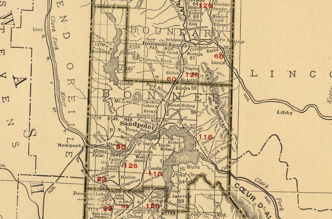
Note: Boyer shows on this map, east of Kootenai
FISHERMAN ISLAND: This island is located on Lake Pend Oreille. It is 3 miles south of Oden. It was named because people fished there for Dolly Varden Trout.
FOREST SIDING: This community is located 7 1/4 miles north to northeast of Sandpoint. It was named because logs were taken there and loaded on the trains.
FOURMILE ISLAND: This island is on Priest Lake. It was named because it is located 4 miles north of Coolin.
FREEMAN LAKE: This community is located just west of Priest River. The grange was organized during 1919 by W. W. Deal and Charles Meeks, who also homesteaded the area during 1893.
GARFIELD BAY: During 1907 this was a steamboat stop on Lake Pend Oreille.
GLENGARY: During 1907 this was a steamboat stop on Lake Pend Oreille. It is located 3 3/4 miles northeast of Midas. The name probably came from an early popular book, "The Man From Glengary", and given by the owners of the first store there. Glengary had a store and post office.
GRANITE: This community is located 22 miles south of Sandpoint at Granite Hill. This village was named for the granite ledges in the vicinity. At first it was an overnight station that assumed more importance during 1874 when gold was discovered on the east shores of Lake Pend Oreille.
GRANITE CREEK: During 1907 this was a steamboat stop on Lake Pend Oreille.
GROUSE CREEK: This community is located 2 3/4 miles east southeast of Samuels and was named for the fauna in the area.
HARLEM: This community was located 2 3/4 miles south of Edgemere.
HOODOO VALLEY: This valley is a natural pathway for traders and trappers of the Hudson Bay Company. The name came from an outfitter by the name of Hoodoo Billy during the early 1880's. This is a 12 mile valley from Kootenai County to the Pend Oreille River.
HOPE: Hope was named after a Northern Pacific Railroad veterinarian, Dr. Hope. Hope was platted in 1888, the year before the railroad company constructed the Highland House, the area's first resort. Miner's, loggers and railroad workers started arriving in the 1860's and 1870's. They traveled up the Clark Fork River from Lake Pend Oreille by steamboats (the Mary Moody, Katy Halet and Prescott) long before the dams were built. David Thompson established a trading post in the 1809's. During 1882 -1883 when the railroad was building a line there was a shortage of men for the work and a need for cheap labor so the railroad brought in roughly a thousand chinese laborers to the area. Many were housed in Hope. During 1907 this town was also a steamboat stop on the lake.
IOLA: This was the original name for the community of Samuels.
INDIAN MEADOWS: The Indian word was Nacemci. This area is located at the mouth of the Clark Fork River where Lake Pend Oreille meets the river near Denton Slough. It was the ceremonial center for the summer and fall festivals for the local indians.
JEWEL LAKE:
KALISPELL ISLAND: Located on Priest Lake 5 miles SW of Nordman. The name came from the name of a local Indian Tribe.
KELSO: A small community 2 miles W to NW of Granite. This community was named for an early pioneer who moved into that area.
KOOTENAI: The original town was located on the Northern Pacific Railroad 4 miles NE of Sandpoint. It was 1 mile east of the present location. Mud Slough (now called Boyer Slough) and Mud Slough Creek formed the natural boundaries to the south and east. During 1883, the small town was referred to as Mud Slough and was a train stop for miners. Alfred Boyer established the first post office and store during 1895.
KULLYSPELL LAKE: This is the old name for Lake Pend Oreille.
Note: No town of Sandpoint and Venton is labeled Ventnor
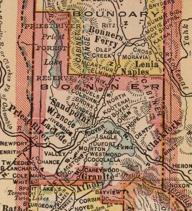
(Click on this close-up map to enlarge in new tab)
Copyright (c) 2000, Mary Garrison
All rights reserved.
Read more history:
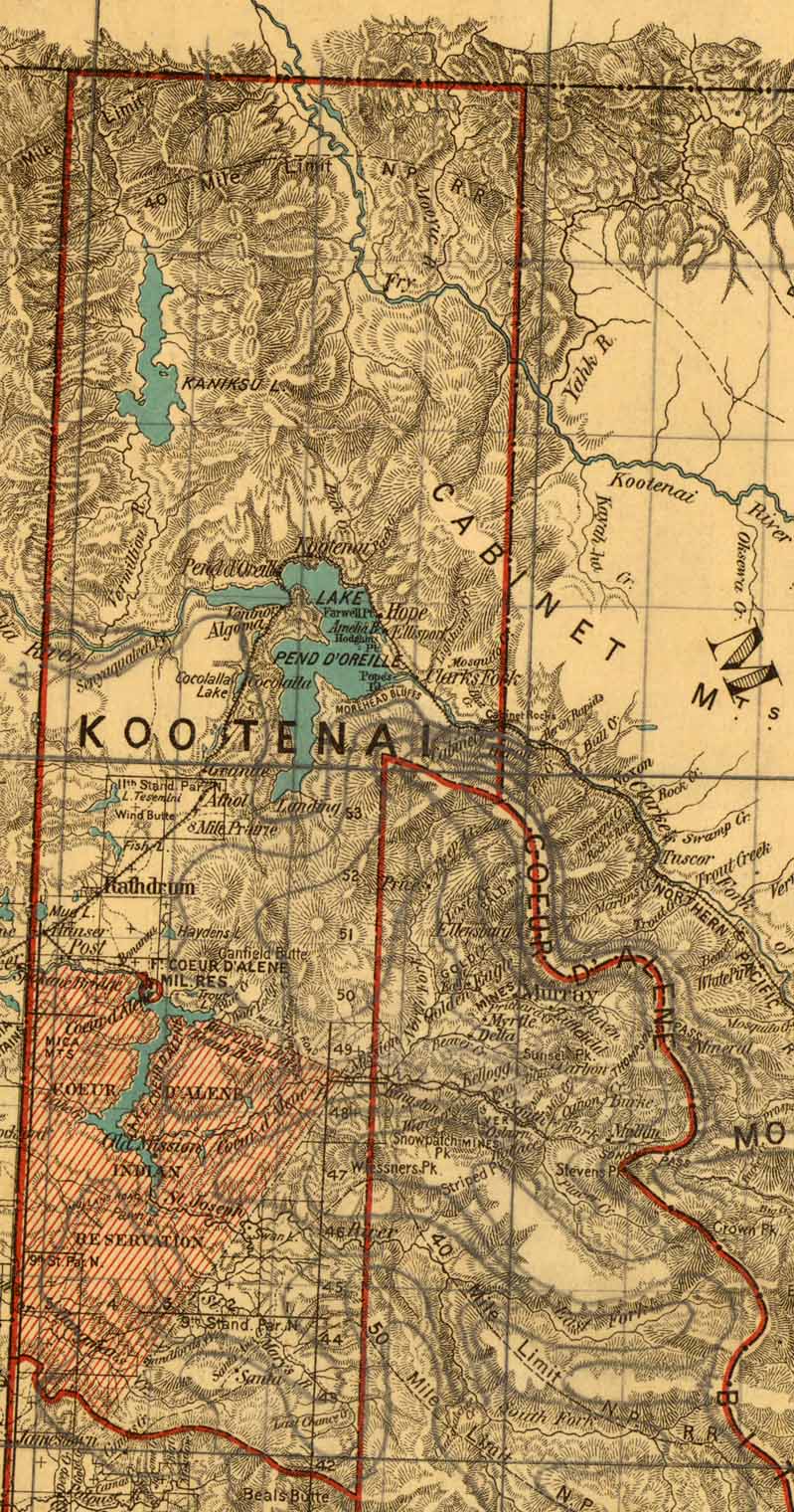
(Click on map to enlarge in new tab)
LACLEDE: This small community is located 7 miles east of Priest River on Hwy 2. It was named in honor of a french engineer by the Great Northern Railroad. During 1922 A. C. White's lumber mill located in Laclede burned to the ground. He decided to move the operation to Dover, ID and barged 56 buildings up river from Laclede to Dover. Today Laclede consists of a post office, bar, gas station, church and Riley Creek Lumber Mill. During its earlier years Laclede was also a ferry landing on the Pend Oreille River.
LAKE PEND OREILLE: (Pronounced Lake Pond - Dor - Ray) Originally the lake was called Lake Kaniksu by Captain E. J. Elliott. During 1905 he had the steamboat "Nancy" that hauled rock for the Spokane International Railroad. It is also believed that the name Pend Oreille came from the French name for the local Indians that wore hanging earrings. During 1907 the steamboat, "The Northern" hauled 250 passengers and freight including mail to Hope and Bayview and to Sandpoint and Lakeview. Frequent stops were Pack River, Cement, Lakeview, Blacktail, Whiskey Rock, Cedar Creek, Granite Creek, Sunnyside, Glengary, Hope, Trestle Creek, Camp Bay, Bayview, Bottle Bay and Garfield Bay. The steamboats operated by this company were "The Western", "The Rustler", "The Bayview" and "The Margaret M". During 1922 this company was hired by A. C. White to transport 56 buildings from Laclede to Dover after his mill burned tot he ground.
LAKEVIEW: During 1907 this was a steamboat stop. It was settled around 1888. The community was first called Chloride due to the influence of the mining industry in the area. The post office was first established during 1892 with Ernest Rammelmeyer as the postmaster. Its present name is derived from its location overlooking Lake Pend Oreille.
LIGNITE: This community is located 2 miles N-NE of Sagle. It is named for the small amount of lignite coal found on a nearby mountain.
MCGUINNES:
MEMALOOSE ISLAND: Located on Lake Pend Oreille.
MIDAS: This community was located on Lake Pend Oreille about 4 1/4 miles N-NE of Talache. It was named for the Midas Mining interest that operated in the area.
MOODY ISLAND: This island is located on Lake Pend Oreille near Hope. It is named for Z. F. Moody, the builder of the first steamboat on the lake.
MORTON: This community was previously known as Valley. The community was later named for the Morton Brothers (George Morton) that homesteaded north of Cocolalla Creek. It was settled in the 1890's by homesteaders. The Spokane International Railroad Depot was at this location in 1906. The post office was added on 06/20/1907.
MUD SLOUGH: This was the original name for Kootenai.
NEWMAN: This community was located on the peninsula in Sagle. It's name was changed to Broten. The original community was named after Jimmy Newman.
NEWPORT: In 1889 a young Irishman, Mike Kelley, built a log store a few feet south of the west end of the bridge at Oldtown, ID. A post office was built in the store in 1890. The homesteaders called this community Newport. Charles M. Talmadge of the Newport Pilot (the weekly paper later called the Newport Miner) started promoting Newport, Washington to Newport, Idaho lost the name and changed the name to Oldtown. (Referring to the old town of Newport).
NORDMAN: This community was named for John Nordman who settled in the area. It currently consists of a store/bar/post office in one building.
NORTHSIDE:
ODEN: This community is located 3 miles N of Sunnyside. During the 1920's this area was stump ranches. They had their own school. A railroad siding was constructed during 1888.
OLDTOWN: Originally known as Newport, ID.
OUTLET:
PACK RIVER: During 1907 this community was a steamboat stop.
PAPOOSE ISLAND: This island is located on Priest Lake about 6 miles SE of Nordman. It is named because it is small like a papoose and looks like it is riding on the back of Kalispell Island.
PEARL ISLAND: This island is located on Lake Pend Oreille about 2 ½ miles S-SW of Hope. It was named for Joe Child's daughter, Pearl. It was previously known as twin island.
PEND OREILLE VILLAGE: The original name for Sandpoint during 1880.
PENINSULA: There are three areas referred to as Peninsula. They are: Hope Peninsula - This area is located east of Hope along Lake Pend Oreille. Sagle Peninsula - This area is east of Sagle Hill bordered by Bottle Bay, Glengary Bay and Garfield Bay. There were post offices at Glengary, Midas and Newman (later called Broten). Priest River - Homesteading started in this area during the 1919's. The community is located north of present day Priest River.
PONDERAY: This community is located 3/4 of a mile west of Kootenai. It was named for the lake but spelled differently.
PRIEST LAKE: Many communities sprung up around the lake. During 1946 the lake itself located in the Selkirk Mountains was named "Roothan Lake" by Father DeSmet honoring his superior in Italy. During 1865 Captain John Mullan, an army road builder, named it Lake Kaniksu. It was later changed to Priest Lake. The Jesuit Missionaries (referred to by the local Indians as Kaniksu or Black Robes) followed the fur traders. During 1913 Sam Tilden Byers homesteaded the mouth of the Thorofare which is the narrow channel that links Upper and Lower Priest Lakes. During the 1930's the Northern Navigation Company had a license to transport passengers on Priest Lake. The steamboat stopped at Beaver Creek, Ranger Station, Mosquito Bay, Two Mouth, Granite Creek, Reader Creek, Eight Mile and Coolin. Elkins Resort was one of the first resorts on Priest Lake. It is located at Reeder Bay. Granite Creek was another resort. Grandview Resort opened during 1936 and Hill's Resort opened in 1946.
Today's community of Priest Lake is referred to by the few businesses along Hwy 57 near Luby Bay Road.
PRIEST RIVER: This town is located 6 1/4 miles east of the Idaho Washington state line and 22 miles west of Sandpoint on Hwy 2. During 1888 settlers moved to an area 1 mile east of the present site. This site was on the west end of Keyser's Slough across the Priest River. They were forced to move in 1890 due to flooding. The city was platted in it's new location during 1901. And had been founded by Henry Keyser. According to the Pend Oreille Review on 07/09/1892 the town started as Priest River. The Great Northern Railroad changed the name to Valencia. Sometime later it was changed back to Priest River.
The river (Priest river) is 67 miles long running from Priest Lake to Pend Oreille River. The first log drive was in 1901 by the White Pine Company Lumber Mill. The last log drive was in 1949. The river was named by Father DeSmet "Rivieres Des Robes" or River of the Priest in French.
PRINGLE: This may refer to Pringle's Addition at East Hope established by Ray and Freda Pringle. The Pringles also gave to the public an area on the lakeshore in East Hope known as "Pringle Park" which embraces the public dock area.
RILEY CREEK: This community was named for John Riley who owned a farm bordering on the creek,.
RIVERSIDE: This community was 7 miles east of Priest River and named for the Riverside Lumber Company which had a sawmill and siding there.
RIVERTON: This community was 1 mile NE of Samuels. It was named by the railroad for it's location near Pack River.
SAGLE: During the Spring of 1884 the first settlers, Mr & Mrs. John Summers, homesteaded 160 acres. This area was referred to as the Village of Sagle. In the 1888's Thomas Turnbull settled Blacktail Mountain. During 1900 the first post office was established by Nathan Powell. He chose the name of Eagle but since it was already taken he changed the "E" to "S" and named it Sagle.
SAMUELS: This community is 11 miles N-NE of Sandpoint. It was called Iola at first and later named in honor of Henry F. Samuels who bought a ranch there in 1913.
SANDPOINT: In 1809 David Thompson noted a point of sand extending into the lake in his journal. During 1880 Robert Weeks opened a store, Great Northern Railroad started the tracks and the town of Pend Oreille emerged. In 1900 Sandpoint was incorporated. L. D. Farmin platted the town in 1898. The first bridge across the lake was called Horseshoe Trestle. The second bridge was built during 1907. During the 1880's Sandpoint was named after the long bar of silvery sand stretching into the lake. The Indian name is Qupquape which means Sandy Place. Sandpoint is the current county seat for Bonner County.
SAWYER: During the 1800's this community was a train stop. In 1904 Louis B. Sawyer started the first post office. It was located 7 ½ miles E-SE of Priest River.
SELLE: This community is currently located 7 miles north of Sandpoint. It was homesteaded between 1898 and 1905 as a farming community. The first homesteaders were Charles Selle, Louise Ameriman, Fred McLain, August Selle, James A. Carnegie, George A. Shurtliff, William E. Cullen, Alexander Duval, and Elmer Sisson. The Spokane International Railroad had cut most of the trees down for ties and left stumps. This is why the area was referred to as the stump farms. During 1912 to 1925 many of the settlers were Scandinavians. They started removing the stumps. The community was named after the oldest settler, Charles Selle.
SENEACQUOTEEN: (Pronounced sin - ee - ack - qwa - teen) During the early 1800's this area was a well liked camping ground for the local Indians. In 1811 it became the first permanent white settlement in the Panhandle of Idaho. It was the first county seat for Kootenai County even though no official business was done there. At this time Pend Oreille River was called the Clark Fork River. A ferry was established between 1860 to 1861 and did business until March of 1957. The only thing today that remains of this community is the cemetery.
SETTLEMENT: (Italian Settlement) During 1891 the Great Northern Railroad construction needed labors. The request was answered by families from Grimaldi, Italy. They settled near Priest River and the community was referred to as Settlement.
SEVERENCE: This is the second name for the community of Careywood.
SNOW VALLEY: This is a community between Priest Lake and Priest River. The first meeting in the grange was during 11/1965 and started by Mr. & Mrs. Dan Robinson.
SOUTHSIDE:
SQUAW VALLEY:
STEAMBOAT LANDING: This was the original name for Cabinet.
SUNNYSIDE: During 1907 this was a steamboat stop on Lake Pend Oreille. This community is located 7 miles east of Sandpoint on Hwy 200. It was named because the area is exposed to the sun during most of the day.
TALACHE: During the 1900's mining started in this area on the shores of Lake Pend Oreille near Sagle. This community is located 5 1/4 miles east of Westmond. It was named after the Talache Mine. The name is Aztec for "tiny one handed silver pick" that the Indians used to get silver from small veins.
THAMA: This area was settled by Franz and Kreszenz Kramer. The Naccaratto's from Italy also settled in this area. It was a ferry landing at one time.
THOROFARE: This is the narrow channel of water flowing 1 ½ miles connection Upper priest Lake and Lower Priest Lake. It was named because the waterway connects the two lakes and makes boat transportation possible.
TRESTLE CREEK: During 1907 this was a steamboat stop.
TWIN ISLAND: See Cottage Island and Pearl Island.
UPPER PRIEST LAKE: This lake located in the north west corner of Bonner County is 3 miles long and 3/4 mile wide.
VALENCIA: This was a name used for Priest River.
VALLEY: The original name for Morton.
VAY: This community is located 3 3/4 miles NE of Edgemere. This was a contraction of the word valley and refers to the valley in which it is located.
VENTON(VENTNOR): This community was a small tent city at the south end of the long bridge across from Sandpoint during the early 1900's.
WELTY: The original name for Dover.
WESTMOND: This community was settled during the 1900's. It is located 2 miles north of Cocolalla. It was named after George Westmond the president of Westmond Lumber Company which had a sawmill there.
WHEATLY: During 1905 Cecil Hutchinson platted the town of Wheatly on Upper Priest Lake. The first building was in 1905. There were 2 streets. Nothing remains of this community today.
WHISKEY ROCK: During 1907 this was a steamboat stop on Lake Pend Oreille.
WHITE PINE: This community was 3 miles north of Careywood.
WILLIAMS: See Coolin.
WRENCO: This community is 10 miles E-NE of Priest River on Hwy 2. It was named for a local incident involving the Great Northern Railroad and a local settler. A train was stopped waiting for a 2nd train to pass on a siding. A cow owned by Constantie Speck was scared of the train and started running down the track. The engineers could hear Speck yelling, "Run, Cow, Run!" The crew named the siding Run Cow which was later changed to Wrencoe and then Wrenco.
WHITE: The original name for Blanchard.
Page updated May 2021


Please, If you would like to add resources, if you know of something that should be linked here or if you have any problems using this website contact us.
Coordinator - Randy Cummings
State Coordinator - Kerry A Hairston